Grossglockner Hochalpenstrasse closes every winter by permission
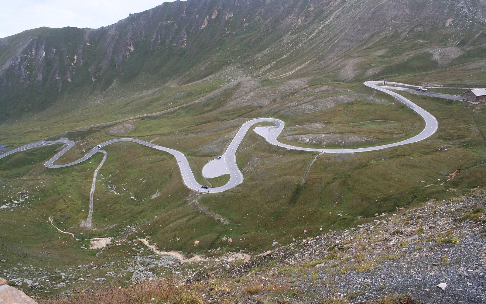
A hairpin road cut into a high alpine slope with a glacier valley beyondPhoto: Grossglockner High Alpine Road · Wikimedia Commons
The Grossglockner Hochalpenstrasse climbs 48 kilometres through the Hohe Tauern to the Franz-Josefs-Höhe, beneath Austria's highest summit. It was engineered in the 1930s, tolled since the day it opened, and closed every winter — because a mountain road is a decision the mountain gets to revisit each year.
Built to be seen from
The Grossglockner is 3,798 metres. It has been Austria's highest peak since measurements became precise enough to settle the question, and it sits at the centre of the Hohe Tauern National Park ↗, the largest protected area in the Alps. The road that brings visitors to its foot was never a working pass road in the agricultural sense — it was conceived and built specifically as a tourist route, which is why it was engineered the way it was: wide enough for two vehicles throughout, with viewing terraces cut into the embankments and a spur road breaking off toward the Pasterze glacier.
Construction began in 1930 under the engineer Franz Wallack, who had been appointed by the Grossglockner-Hochalpenstrassen AG — the joint-stock company formed to finance and build it — and who oversaw every metre of its alignment. The road was opened in stages: the main ridge crossing in 1935, the Franz-Josefs-Höhe spur in 1935 as well, the whole system complete by the time visitors arrived in numbers for that summer season. The workforce at peak construction numbered around 3,200 men, many of them unemployed tradesmen from the valley towns, working in conditions that the altitude alone made unusual. Rock was blasted by hand drill and compressor; spoil was shifted on light-gauge track wagons before the road surface existed to carry trucks.
The geometry is the achievement. Wallack's alignment gains roughly 1,400 metres of altitude from the Zell am See side and around 1,300 metres from the Carinthian side, in a road that never resorts to gradients extreme enough to stop a laden vehicle — the maximum is around twelve percent on the steepest ramps. To hold that discipline across difficult terrain the road makes long, sweeping traverses, cuts into cliff faces, and crosses its own alignment twice on the Fuscher Törl section, spiralling upward in a double loop that is the visual signature of the whole route. Twenty-nine bridges, dozens of retaining walls and several short covered galleries carry it through terrain that would otherwise simply not accept a road.
The toll and what it pays for
The Grossglockner Hochalpenstrasse has been a toll road since 1935 — one of the oldest continuously operating mountain toll roads in Europe ↗. The tolls are not a revenue stream extracted for general use; they fund the road's own maintenance, the payroll of the snow crews and road staff, the drainage infrastructure, and the ongoing engineering work that a road at this altitude requires every single year. The Grossglockner-Hochalpenstrassen AG remains the operating body, as it has been since the beginning, now majority-owned by the state of Salzburg and the state of Carinthia jointly, since the road crosses the provincial border at the Hochtor tunnel.
The Hochtor, at 2,504 metres, is the high point: a short tunnel that punches through the main ridge of the Hohe Tauern, crossing from Salzburg into Carinthia. On the Carinthian side the road descends to Heiligenblut; on the Salzburg side it drops back toward Bruck and the Salzach valley. The Franz-Josefs-Höhe spur branches south from the main road at the Guttal junction, climbs to 2,369 metres and ends at a terrace above the Pasterze — the longest glacier in the Eastern Alps. The Pasterze has receded dramatically over the lifetime of the road. Photographs taken at the opening in 1935 and compared with recent ones show the glacier surface has dropped many tens of metres and retreated a substantial distance up-valley. The viewing terrace at the Franz-Josefs-Höhe was built at a height that once looked out roughly level with the ice; it now looks down at it from considerably above, across bedrock that has only been ice-free within living memory.
- St. Anton
- Eibsee
- Garmisch
- Achensee
- Mayrhofen
- Grossglockner
- Königssee
- Bad Gastein
A funicular, the Gletscherbahn Pasterze, descends from the terrace to a point near the glacier margin. It was built because the glacier was receding and the walk from the terrace to the ice surface was becoming impractical without mechanical assistance. That a descent mechanism was added to make the ice reachable says something precise about the pace at which the landscape around the road has changed since Wallack's crews finished the stonework.
The closing and the opening
Rock was blasted by hand drill and compressor; spoil was shifted on light-gauge track wagons before the road surface existed to carry trucks
The road shuts for the winter. This is not an administrative inconvenience — it is a structural fact of the road's design and location. The Grossglockner Hochalpenstrasse typically closes in November and reopens in May, though the exact dates move with the snowpack, which moves with the year. Neither date is fixed in a calendar; it is fixed by an inspection. The road's operating company sends crews up in spring to assess the surface after winter — damage from frost-heave, debris from slides, stonework that has moved, drainage blocked by ice. The opening is confirmed when those checks are completed, not before.
During the closure, the snowpack on the road reaches depths that make the surface irrelevant. At the Hochtor and along the exposed traverses below the Edelweisspitze viewpoint, the snow accumulation can reach several metres. The spring opening involves days of mechanical clearance to cut the road out from under it — a sequence of work that the snow crews carry out each year as a matter of course, a job whose scale is invisible to the visitor who arrives in June and sees only a clear grey ribbon across a white landscape.
The road is engineered for traffic it carries for roughly half a year. The other half, it belongs to the mountain: buried, compressed, scored by rockfall, and gradually assessed for what repairs the next season will require. The decision to open is made by people who have looked at the road, not by a calendar. That model — a road that operates on permission — is what gives the Grossglockner Hochalpenstrasse its character. It is not merely a scenic drive through the Hohe Tauern. It is a physical argument, made in stone and asphalt, about where a road can go and on what terms the mountain agrees to carry it.